
Navigation from low Earth orbit: why GPS backups are becoming a business
Key takeaways
- Xona Space Systems raised a $250 million Series D at a $2.45 billion valuation on October 22, 2026, bringing its total raised to more than $570 million.
- Its Pulsar network uses satellites in low Earth orbit to offer stronger, more precise and harder-to-jam positioning and timing than legacy GPS, according to the company.
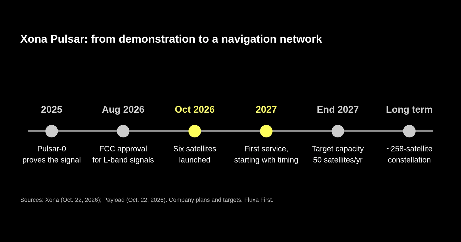
- Six satellites launched in October, four of which are due to begin customer service in 2027; the long-term plan is a constellation of about 258 satellites.
- We see resilient positioning and timing as core infrastructure for autonomy, energy and logistics, and a model for commercial companies filling gaps once left to governments.
Almost everything that moves or keeps time depends on satellite navigation: aircraft, ships, trucks, drones, farm equipment, power grids, telecom networks and financial systems. Most of it relies on GPS signals that are weak by the time they reach Earth and are vulnerable to jamming and spoofing. On October 22, a startup building an alternative from low Earth orbit announced a $250 million raise, a sign of how resilient positioning and timing is turning into a commercial business.
What did Xona announce?
On October 22, Xona Space Systems announced a $250 million Series D at a $2.45 billion valuation, led by Future Ventures. The company says it has now raised more than $570 million since it was founded in 2019.
The money arrived as Xona started deploying its network. Days earlier, it launched six Pulsar satellites. Four of them are due to begin serving customers in 2027. The other two are test satellites, the first designed and built entirely in-house at its Burlingame, California factory, built around a design the company says is optimized for producing several satellites per week. According to Payload, the satellites flew on SpaceX’s Bandwagon-5 rideshare, Xona plans a constellation of about 258 satellites, and its chief executive said the goal is capacity to build 50 satellites a year by the end of 2027.
What does Pulsar claim to do better?
Xona says its demonstration satellite, Pulsar-0, has run more than 500 transmissions since launch last year, shown positioning accuracy better than two centimeters, performed better than traditional satellite navigation in difficult environments, and worked with existing commercial receivers upgraded without hardware changes. Payload reports the company says its signals are up to 100 times more powerful than legacy GPS, which could help with indoor reception and resistance to jamming. In August, Xona became the first commercial navigation constellation to win FCC approval to broadcast L-band signals, according to Payload. The approval is conditional: it initially covers 16 spacecraft, with further approval needed for the rest of the 258.
These are company claims about a network that is only starting service. The proof will come in 2027, when paying customers use the signal. Xona says it will start with a timing service, and Payload reports it plans to test integrations with Army, Navy and Air Force systems next year.
Why is resilient positioning and timing a real market?
GPS interference is not hypothetical. A GAO review found that the Department of Transportation identified 196 potential GPS interference incidents from January 2020 through May 2022, and that its process likely missed others. GAO called for a strategic approach to resilience, and DOT published a positioning, navigation and timing strategic plan in December 2024.
Since then, demand has broadened. Xona’s chief executive told Payload that government interest rose after jamming and spoofing in places such as the Strait of Hormuz, which he said has disrupted navigation for more than 2,000 ships. On the commercial side, he pointed to autonomous vehicles, robotics, aviation and critical infrastructure. Each of those needs not just a position, but one it can trust.
What should founders and investors take from Xona?
Infrastructure can be commercial. Satellite navigation used to be something only large governments built. A company that rethought the satellite, signal and ground system together, in low Earth orbit, is working to turn it into a service for private customers. Many other kinds of infrastructure once left to governments, from weather data to grid monitoring, are open to the same approach.
Adoption runs through existing devices. Xona’s emphasis on working with existing commercial receivers is a distribution strategy, not just an engineering detail. A new signal that needs new hardware in every device faces a much slower path. Hard-tech founders should ask early what their customers already own and how to fit into it.
Regulatory approvals are part of the moat. Spectrum licenses and FCC authorization take years and are hard to replicate. Treat them as milestones on the roadmap, alongside technical ones.
Production cadence is the next test. Moving from a handful of satellites to hundreds means building a factory and a supply chain, not just a design. That is the same transition we see across hard tech, from launch to drones, and it is where many well-funded companies stumble. We wrote about related constraints in launch infrastructure and the drone components industrial base.
How we see it
Trusted positioning and timing sit under almost all of aerospace, autonomy and the infrastructure that ties them together. A world of autonomous ships, aircraft and robots needs navigation that keeps working when signals are contested, and an energy and telecom system that depends on precise timing needs more than one source.
Resilience is a sovereignty question as much as a technical one. Our view is that the United States is stronger when critical capabilities come from several sources, including competitive American companies that can improve at commercial speed. Xona’s raise is a sign that investors increasingly agree. The next two years will show whether the service can match the plan.
Frequently asked questions
What is LEO navigation?
LEO navigation uses satellites in low Earth orbit, a few hundred to about two thousand kilometers up, to broadcast positioning and timing signals. Because the satellites are much closer than GPS satellites, signals can arrive stronger at the receiver, which can improve accuracy and resistance to jamming. Several companies and governments are developing such systems.
Will LEO navigation replace GPS?
Not in the near term. Companies such as Xona describe their systems as a complement and an upgrade for users who need more precision or resilience. GPS remains free, global and built into billions of devices, so most users will rely on several sources together.